

Landscape Fund projects in Lower Austria
LAFO Project "The farmer as knowledge broker"
![]() Services of the Landscape Fund project "The farmer as knowledge mediator" on the subject of soil health and food using the example of GRAND FARM:
Services of the Landscape Fund project "The farmer as knowledge mediator" on the subject of soil health and food using the example of GRAND FARM:
- Self-sufficiency - cucumbers
- Self-sufficiency - peppers
- Self-supply - carrots
- Self-supply - runner beans (runner beans)
- Self-sufficiency - tomatoes
- Training unit on soil cultivation and soil structure
- Training unit Introduction to refinement
- Composting and worm composting training unit
- Training unit Introduction to self-sufficiency
- Training unit Use of mulch and soil protection
- Training unit on market gardening
Videos:
Marktgärtnerei - LAFO Kurzfilm
Selbstversorgung - LAFO Kurzfilm
-------------------------------------------------------------------------------------------------------------------------
Drechsler Carbo Hedge Study: CO2 Sequestration by Hedges - How much Climate Protection is possible?
Reports: Agroforestry - Root Competition and Water Erosion Reduction through Agroforestry Systems in Lower Austria, Evaluation of Humus Enrichment with Organic Fertilizers in low-farming Regions of Lower Austria, Demonstration Farms for Multi-use Hedges in Lower Austria as a Model for the EU Mission Soil Health and Food
Click here to go directly to the reports:
>> Evaluation of humus enrichment with organic fertilizers in low-farming regions of Lower Austria
Soil Condition Changes in Landscape Areas of the Industrial District - Final Report of the Landscape Fund Project from February 2024
Further information can be found in the final report of the Landscape Fund project from February 2024
New Article in Geoderma: SOC:Clay Ratio: A Mechanistically-Sound, Universal Soil Health Indicator Across Ecological Zones and Land Use Categories?
New article in Geoderma: SOC: Clay Ratio: A Mechanistically-Sound, Universal Soil Health Indicator Across Ecological Zones and Land Use Categories?
from Wenzel, Walter and Golestanifard, Alireza and Duboc, Olivier
Available at SSRN: https://ssrn.com/abstract=4725180 or http://dx.doi.org/10.2139/ssrn.4725180
New Article: Pedogenic controls of soil organic carbon stocks and stability beneath montane Norway spruce forests along a precipitation gradient
Your article link: https://authors.elsevier.com/sd/article/S2405-8440(23)08492-X
Carbon Sequestration Potential and Fractionation in Soils after Conversion of cultivated Land to Hedgerows - neuer Artikel im Journal GEODERMA
>> to the article: Carbon sequestration potential and fractionation in soils after conversion of cultivated land to hedgerows - ScienceDirect
Brochure "Targeted humus management in Lower Austria's soils
The new brochure "Targeted humus management in Lower Austria's soils" as a starting signal for more comprehensive humus build-up by farmers in Lower Austria.
Within the framework of the project of the same name, supported by the Lower Austrian Landscape Fund, the brochure "Targeted humus management in Lower Austria's soils - guidelines and best practice examples, developed with 81 practical farms" has been completed by Bio Forschung Austria and can be downloaded with the following link.
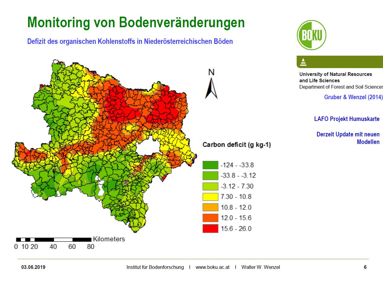
To this end, Prof. Walter Wenzel and his working group first developed carbon deficit maps with soil type-specific evaluations that support targeted humus enrichment in regions in need of humus. Thus, the Weinviertel, the Tullnerfeld and the central Alpine foothills were identified as the regions with the highest carbon saturation deficits and the greatest need for comprehensive areal humus enrichment.
For these regions with about 300,000 ha of arable land, the results of the farm-wide humus balances, which were compiled with the significant voluntary cooperation of 81 farms, were summarized in an overview of the current state.
These overviews show that in these regions, with the current management, a negative humus trend is still to be expected on almost half of the arable land.
Humus balancing allows estimating the humus trend on cropland based on past management. This method can also be used to estimate the effects of a planned change in management and, for example, to mathematically test various options for maintaining or increasing soil humus content.
During humus balance seminars and the on-farm surveys, suggestions were made to the 81 farmers for measures to improve their humus balance and increase soil humus content on their cropland. These measures were discussed with the farmers and checked by them for their feasibility.
On this basis of the improvement measures discussed with and reviewed by the farmers, region-specific proposals for measures were compiled for these regions. And for each of the 81 farms in the regions Weinviertel, Tullnerfeld and central Alpine foothills, optimization variants for humus management are available, for which the feasible optimization steps for the farm were filtered out together with the farm managers. These show how high the optimization potential realistically is.
20 best-practice examples of farms and their optimization measures round off the brochure and should provide sufficient and comprehensive inspiration for all who manage soil!
The humus balance calculation for a farm can be done very easily with the help of the humus balance calculation program created by Bio Forschung Austria. This requires appropriate training on the subject of humus and the correct handling of the program. Dates of humus balance seminars can be found at www.bioforschung.at.
In advance, however, every interested farm should download the brochure "Targeted humus management in Lower Austria's soils" via the link, so that the starting signal can be given for the most comprehensive humus build-up possible by farmers in Lower Austria.
Download brochure (in German) >> here
Potential Analysis of Soil Data of Lower Austria in Connection with EU Soil Data
A range of soil information exists in Austria, each available source of soil information is naturally created with different objectives. Accordingly, all data, apart from the data content, are available in different accuracy, as well as different spatial and temporal resolution. A major problem is the lack of temporal and spatial repetition of virtually all available data sets. Long-term repetition of data collection in the field of soil information is of particular importance, since our soil is a dynamic system that reacts slowly to changes.
The importance of soil protection and the various approaches to it were elaborated on the basis of 3 examples. Different spatial scales (national - regional - local) were considered, as well as different areas of activity (technical - institutional).
A national consideration of soil hazards cannot avoid looking at Europe-wide initiatives as well. The Lucas project (Land use/cover area frame survey), which comprises 20,000 measuring points in Europe, 420 of which are sample points in Austria, should be emphasized here. This involves sampling the topsoil (0 - 20 cm). Of course, this system is also fraught with problems, the main challenges here being the sole sampling of the top 20 cm of the soil profile and the low density of sampling. On the plus side of the Lucas project is the regular sampling of sample points at 3 - 6 year intervals.
The results show that a significant loss in quality of information on magnitudes and regional differences in soil loss should be expected when using Lucas data sets.
Another aspect of the potential analysis of soil data concerns the institutional background of soil protection activities in Lower Austria. Here, the example of the agricultural district authority was used to show which funding possibilities and target groups are addressed by this institution.
The local aspect of soil protection was dealt with using the example of the hydrological catchment HOAL Petzenkirchen. In the HOAL Petzenkirchen the soil loss since 1945 was quantified. A comparison of the water-related soil losses (= sediment), for the periods 1945-1954 and 2002-2017 showed that the sediment concentrations in the receiving water of the HOAL Petzenkirchen have increased enormously. Although the change in regenerosivity in the catchment has increased significantly in the last two decades, this occurred only after a significant decrease in erosivity in the 1960s and 1970s. This implies that climatic influences have not contributed significantly to the increase in soil loss.
A major contributor to the increase in erosion risk has been, on the one hand, the change in crop composition toward increased cultivation of crops with higher erosion risk. On the other hand - and here we come full circle to the institutional soil protection by the ABB - the natural conditions in the watershed, i.e. the presence or absence of small and many sloughs, e.g. with marginal boundaries, were a very important driver for the increased soil loss to the water bodies.
>> PDF Report Potential analysis ground data - November 2021 (GE)


Photos: ©BAW Petzenkirchen, Hydrologisches Einzugsgebiet HOAL – Hydrological Open Air Laboratory Petzenkirchen
Carbon in Lower Austrian Soils - new Article in the Journal GEODERMA
Soil and land use factors control organic carbon status and accumulation in agricultural soils of Lower Austria
Walter W. Wenzel, Olivier Duboc, Alireza Golestanifard, Christian Holzinger, ... Anna Schiefer
Article 115595
Further information in the journal GEODERMA published article at:
https://authors.elsevier.com/sd/article/S0016-7061(21)00675-3
>> Article as pdf
Project AustroPOPs shows Situation on Organic Pollutants in Soils in Austria
They occur everywhere, can be transported over long distances and accumulate in the food chain: organic pollutants pollute the environment and also enter our soils via various input pathways.
In the AustroPOPs project, the federal and state governments jointly created essential foundations for the uniform monitoring of organic pollutants in soils.
The final report of the federal-state project is now available online.
Information on the project, on the report: AustroPOPs (bodeninfo.net)
Soil Monitoring Lower Austria
Soil Condition Inventory
At the beginning of the 1990s, a soil condition inventory was carried out for the first time in Lower Austria to record general soil parameters at a total of about 1450 sites. Since, based on the relevant scientific literature, it can be assumed for most of the soil properties recorded in the BZI that changes only occur gradually over long periods of time and can thus be statistically validated, a re-sampling was planned for longer time intervals. This started after 30 years at the beginning of 2020. Currently, topsoil samples are resampled at 300 locations in the Pannonian region (Chernosem region) and examined for the characteristic values of organic carbon, nitrogen, selected metals and metalloids. The evaluation opens up the possibility to identify changes in the investigated parameters over the last 30 years.
Repeat sampling of soil mapping sites in Lower Austria
In the period 2016-2019 >600 profile points of the Austrian soil mapping in Lower Austria were sampled again. Top soil samples were taken from cropland and grassland locations for which archive samples from the initial sampling are still available. The investigations include soil acidity (pH-value), carbonate, organic carbon and nitrogen, as well as nutrients that are potentially available to plants (phosphorus, potassium and silicon).
Mapping and modelling of carbon saturation potentials and deficits
Based on the BZI Lower Austria, the saturation potentials were derived from the grain fraction <20 µm (clay, fine and coarse silt) using model calculations and GIS-based interpolation for the whole of Lower Austria with the help of a landscape model in high resolution. Furthermore, the saturation deficits were calculated from the difference to the organic carbon contents collected in 1990 and also converted into a high-resolution map by means of a landscape model.
Soil monitoring and monitoring of organic pollutants in Lower Austrian soils
In the central settlement and economic areas of Schwechat and Tullner Feld, a total of >50 soil monitoring plots have been set up since the end of the 1990s according to the concept of Blum et al. (1996), some of which have been sampled several times. The measured parameters include pH values, organic carbon and carbonate as well as inorganic (heavy metals and metalloids, fluorine) and organic (PAH, dioxins and furans, BTEX, PCB) pollutants. As part of the Austro-PoPs project, some of the areas were sampled again in 2019.
Nutrient dynamics in soils of Lower Austrian agricultural landscapes

Supported by the Lower Austrian Landscape Fund (LAFO)
Christian Holzinger, B.Sc.1,
Walter Wenzel, Univ.Prof. Dipl.-Ing. Dr.nat.techn.1
1 University of Natural Resources and Applied Life Sciences Vienna, Institute for Soil Research, Konrad Lorenz-Straße 24, A-3430 Tulln an der Donau
The current condition of the investigated arable land classified as good for organic carbon. Only 5% are in the lowest class. The same applies to the C/N ratio, only 9% have a slightly too wide ratio. The pH value divided into 24% in the acidic, 22% in the neutral and 54% in the alkaline range. Phosphorus availability shows an undersupply for almost 50% of the sites, while 32% sufficiently supplied and 20% are oversupplied. For potassium availability, 38% are in the low range, 33% adequately supplied and the remaining 29% in the higher ranges. For the available silicon fraction, a differentiated picture emerges depending on the assumed limit value. While only 12% are below 20 mg/kg (sugar cane), 60% are below 43 mg/kg (rice).
For the current condition of the grassland sites investigated, only the organic carbon and the C/N ratio are in a good range. The majority (69%) of the sites have an acid soil reaction. The proportion of 26% in the strongly acidic range is high. For the plant-available phosphorus is a low supply indicated. 91% are under-supplied, 5% sufficiently supplied and 4% in the high and very high range. Potassium availability is 48% in the undersupplied range, 26% considered adequately supplied and 26% classified as oversupplied. The availability of silicon shows a poor picture (at the assumed limits 60% are < 20 mg/kg and 98% < 43 mg/kg).
The investigation into possible changes in soil parameters over time in arable farming could only detect a significant change for the CN ratio. The available phosphorus decreased slightly (not significantly). The number in the lowest content classes A and B increased, the proportion of sufficiently supplied class C remained stable and the oversupplied classes D and E decreased. The organic carbon content showed a non-significant increase in the median, from 20.5 to 22.9 g/kg.
In grassland, there was a significant increase in soil organic carbon, total nitrogen, CN ratio and a very large increase in available potassium (median almost quadrupled). The pH and the amorphous silicon fraction decreased significantly. The available phosphorus increased slightly (not significantly). Thera are no changes for the potentially available silicon fraction.
When considering changes over time in geographical areas, the values determined for arable land and the main production area " North-Eastern Plain and Hill Country " (HPG 8) and the small production areas "Vienna Soil" and "Baden-Gumpoldskirchen Area" (KPG 809 - 810) could be compared well with that of the ÖPUL evaluation (AGES, 2010).
In the small-scale production areas "Vienna Soil" and "Baden-Gumpoldskirchen Area", the pH values remained largely stable in the carbonate buffer range. The organic carbon content increased somewhat (median 34.2 to 39.5 g/kg), although the increase could not be statistically verified. The total nitrogen contents remained almost constant (3.1 and 3.4 respectively). The proportion of the content classes of plant-available phosphorus decreased into the low - and sufficiently supplied range. For potassium availability, there was a decrease in the under-supplied classes (A and B) and a slight increase in the sufficiently supplied class C, as well as in the higher classes (D and E). The silicon fractions show no significant changes over time. In the main production area "North-Eastern Plain and Hill Country", there was a relevant, statistically at present still scarcely reliable increase of 15% in the median values of the organic carbon content.
The values determined for the main production area "Voralpen" (HPG 2) were far below the values of the ÖPUL evaluation. One reason could be the high number of soils with hydromorphic characteristics in the renewed sampling of the agricultural soil mapping. The water balance and the associated air balance are of immense importance for biogeochemical soil reactions. If there is no relatively homogeneous distribution of important soil characteristics, or also soil types (in Austria according to genetic characteristics), this can also lead to non-comparable soil data. Especially the water balance (and air balance) can be attributed an important role in this respect.
The pH value shows a significant decrease (median from 5.9 to 5.4). Organic carbon (median from 37.6 to 54.6 g/kg) and total nitrogen (median from 4.1 to 5.5 g/kg) have increased significantly. The C/N ratio has improved significantly, and is now in a better range. Phosphorus availability has not improved and the majority of soils are in the undersupplied range (94%). Potentially plant-available potassium shows a strongly significant increase (median from 21.8 to 84.6 mg/kg), and the distribution in the content classes has improved. For silicon availability, no significant change is shown (median from 14.9 to 15.6 mg/kg). The amorphous silicon fraction shows a significant decrease (median from 2290 to 1980 mg/kg).
The increase in organic carbon content in both land use types (arable land and grassland) assessed positively. The increase in arable land is in line with the results of AGES (2015). It pointed out that the data on organic carbon in particular are preliminary evaluations, as only part of the analytical data is currently available.
Map with new sampling in Lower Austria
The map shows the locations of the basic programme of soil monitoring activities of the province of Lower Austria in cooperation with the Institute of Soil Research of BOKU at the Tulln site (UFT). Based on the sampling network of the Lower Austrian Soil Condition Inventory (BZI - grey squares), numerous sites in the Pannonian region were initially re-sampled in 2020 to determine changes in soil properties over time. In addition, about 600 soil profile sites of the Austrian Soil Mapping re-sampled in 2016-2020 to further densify the measurement network. Both for the BZI and for the shown soil mapping locations, archive samples hold on behalf of the province of Lower Austria at the BOKU Tulln (UFT) site and analyzed for comparison with the newly taken samples.
The current analysis programme aims at determining the current soil condition and its changes during the last decades with regard to important parameters such as organic carbon (humus), soil acidity (pH), carbonate content, as well as available nutrients (nitrogen, phosphorus, potassium, silicon) and potential pollutants (arsenic, heavy metals).
The measuring network shown here is supplemented by permanent soil monitoring plots (above all in central settlement areas such as the districts of Tulln and Schwechat) and further investigations at selected sites (organic pollutants; monitoring of soil protection facilities, networking with European monitoring programmes such as LUCAS, etc.). Thus, in accordance with the Lower Austrian Soil Protection Act, soil monitoring is as comprehensive as possible, taking into account new scientific findings.
Download map with new sampling in Lower Austria (pdf)
Project Loess Paleosol Map of Lower Austria
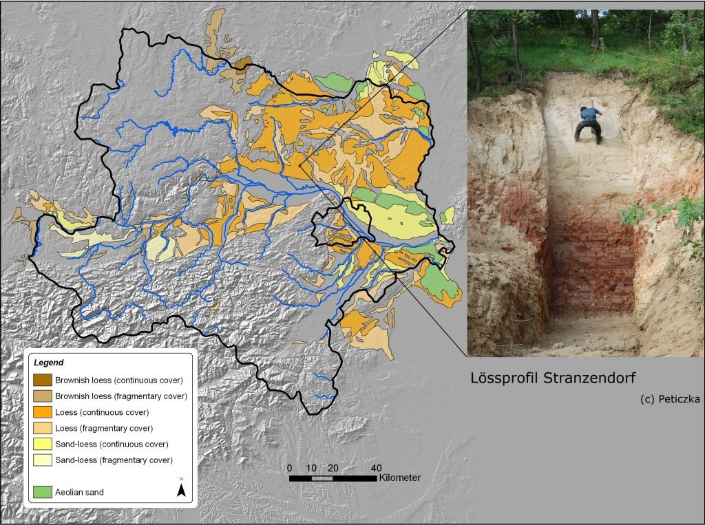
Lower Austrian soils on loess substrates have a high silt content and, although prone to erosion, are particularly well suited for viticulture.
Significant archaeological finds are repeatedly made in loess deposits, and they also reveal important climatological or environmental-historical information.
Picture: The LPS Stranzendorf with a mighty "tropical" paleosol.
Paleosols, on the other hand, originated from soil-forming processes during the warm periods and contain immanently important information about site and environmental conditions for science.
Some of the world's most significant loess paleosol sequences (LPS) are found in Lower Austria. Quaternary geological information is permanently stored in these profiles, allowing statements to be made about the historical landscape development of Lower Austria - and more broadly for Central Europe.
A large number of inquiries from domestic and foreign researchers concerning these "hard drives of nature" confirm the interest and international importance of these Lower Austrian type localities. In many cases these are the profiles of Willendorf, Stranzendorf (see picture), Krems and Stillfried.
All these sites have in common that they are repeatedly in the center of recent scientific publications on international, national and local level.
In this project of the Lower Austrian government the distribution of the different solution types of Lower Austria and their included paleosols will be presented in a digital map. The data will be stored in a geoinformation system and will be adapted for different uses and can be supplemented continuously.
Ass.-Prof. Mag. Dr. Robert Peticzka
Althanstraße 14 (UZA II)
1090 Wien
Room: 2A391
T: +43-1-4277-48670
M: +43-664-60277-48670
robert.peticzka@univie.ac.at
Universitätsstraße 7 (NIG)
1010 Wien
Department of Geography and Regional Research
https://geographie.univie.ac.at/en/
https://geographie.univie.ac.at/en/working-groups/geoecology/
Overview Map of Soil Types for Lower Austria created

On behalf of the Department of Land Development of the Lower Austrian Agricultural District Authority, Walter Wenzel from the Institute of Soil Research at BOKU Vienna, Rosemarie Hösl and Peter Strauss from the Federal Office of Water Management, together with M. Englisch, E. Herzberger and R. Reiter from the Federal Office for Forests, created a comprehensive soil mapping based on the detailed information of the Austrian Soil Mapping for the Province of Lower Austria using scientific methods.
On the basis of the new soil map, five soil regions can be distinguished in Lower Austria, which are further divided into a total of 21 small soil regions (see picture).
The created map on a scale of 1:900,000 is intended as an essential basis for further scientific work as well as for the in-depth interpretation of soil condition surveys. Last but not least, the new soil map can be used to better inform the public and awaken soil awareness in the context of school education or for exhibitions.
Download: Explanations of the Lower Austrian Soil Map (pdf)
Download: Print version of the Lower Austrian Soil Map (jpeg)
Download: Print version of the Soil Map A3 (pdf)
Soil Hydrological Data
"Hydrological soil parameters, such as hydraulic conductivity (ability of the soil to conduct water to depth), total pore volume (air space within the soil body) or usable field capacity (water storage capacity of the soil) represent an important database for applications in hydrological practice. Numerous models for the prediction of flood events are based on these parameters. In the first phase of the project HYDROBOD-NÖ such parameters could be compiled for the whole province of Lower Austria. Since completion of the first phase of HYDROBOD (2011), further parts of Lower Austria could be surveyed by agricultural soil mapping. These new bases have now been incorporated into the existing database, resulting in a significant improvement of data quality in the newly mapped areas.
Data packages for download:
- Reports from both project phases - Download hydrological soil characteristics Lower Austria - HYDROBOD NÖ II, second project phase
- Download hydrological key data of the soils of Lower Austria (HydroBodNÖ)
- Download Hydrological soil characteristics of the soils of Lower Austria (HydroBodNÖ) short version
Download maps Hydrobod II (zip file): Maps in jpg format (A2) for the parameters: soil storage, total pore volume, storage effective soil thickness, topo index
Download maps Hydrobod I (zip file): Maps in jpg format (A2) for dominant runoff processes with (mv) and without (ov) silting for heavy rain events of different duration (15 min, 60 min, 12 h) D = 100 years
Download Rasterdaten Hydrobod II Metadaten: ods-Datei in Tabellenform mit Beschreibungen und Metadaten der einzelnen Rasterdatensätze
Download raster data Hydrobod II metadata: ods file in tabular form with descriptions and metadata of the individual raster data sets
Download here:
http://www.noe.gv.at/noe/OGD_Detailseite.html?id=203fbf07-9da2-40d2-bc7f-328dae43dafc
15.-16.10.2024
Bodenforum Österreich - Herbsttreffen
more ...26.+27.09.2024
ELSA Jahrestagung
more ...26.09.2024
555 x Paradies-Genüsse - Obstvielfalt entdecken und schmecken
more ...24.+25.09.2024
31th Conferece of the Danube Region
more ...21.09.2024
Fest der Obstvielfalt im Alchemistenpark
more ...17.09.2024
ÖBG Jahrestagung 'Mission Soil.at'
more ...13.-15.09.2024
Mein Beeren- und Obstparadies
more ...11.-13.09.2024
Tropentag 2024
more ...06.-09.2024
ernte.dank.festival. am Wiener Heldenplatz
more ...06.08.2024
Erdfarben Workshop
more ...27.06.2024
Seminar Wildbienen- und Nützlingsförderung im Biolandbau
more ...20.06.2024
ÖKL Praxisseminar Bewässerungstechnik
more ...17.06.2024
ÖKL Kolloquium 2024 - Jeder Tropfen zählt! Effizientes Wassermanagement in der Landwirtschaft
more ...14.06.2024
Artenvielfalt in Ackerbauregionen fördern
more ...05.06.2024
Exkursion Mehrnutzenhecken
more ...04.06.2024
Agroforst Vernetzungstreffen - Stammtisch
more ...04.06.2024
Besuch von Agroforstbetrieben in NÖ
more ...03.06.2024
Seminar Malen und Gestalten mit Erdfarben
more ...28.05.2024
Keine Angst vor der Ackerdistel
more ...24.05.2024
RABS - Regional angepasstes Begrünungssaatgut
more ...